The objective of the Egnatia Motorway Observatory is to collect and process data, and calculate indicators to be used for monitoring the long-term impact of the motorway on the territorial cohesion, the urban and regional planning, the system of transport, and the environment.
The Observatory is being developed as a strategic tool providing information and support to policies and programmes of development planning, at the service not only of the EGNATIA ODOS S.A. but of all Regional and National Authorities and development agencies of the greater impact area of the motorway.
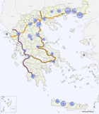
The Egnatia Motorway is not simply a modern motorway. The first question asked by everyone may well be directed at issues such as the progress of the actual operation of the 670 kilometres of its total span, but the real stake lies with issues relating to its wider contribution in terms of the development of the area within its sphere of impact. The Egnatia Motorway system with its vertical axes constitutes a development plan in its own right, with implications not only for the transport and communication systems but also for spatial structure and for the environment, and it provides at the same time opportunities for the broadening of economic and cultural exchanges with the neighbouring Balkans. This development-oriented dimension of the Egnatia Motorway project is, moreover, taken into consideration within the broad scope of policy making, as much at a regional and local level as in national and even European terms. The expectations to which the Egnatia Motorway has given rise, as a backbone of regional development, bring up for discussion the need to start on a course of coordinated action and effective collaboration involving the public and private agents if the advantages it offers are to be fully exploited.
The Observatory stands as an innovative initiative on the part of Egnatia Odos S.A. in so far as it responds in practical terms to the perceived necessity of evaluating and monitoring the spatial impacts of the Egnatia Motorway. This is carried out in full harmony with the endeavours to assess the impact produced by the Trans-European Networks on development and cohesion at the European scale. In other words, the Observatory is developing into a strategic tool of information and support for policies and programmes of regional and spatial planning, at the service not only of the Company’s Management, but also of all the Regional and Civil Authorities and development agents in the wider area of influence of the axis. The continuous recording, monitoring and analysis of the impact of the Egnatia Motorway are based on a system of indicators, by applying scientifically documented specifications, methods and tools of analysis which characterise current international good practice.
The activities of the Observatory are structured on a 5-year Action Plan basis. The main components include:
• Enhancement and organisation of public data, digital files and a mapping database through the development of Spatial Database Engine and WebGIS system.
• Calculation and monitoring of the 50 spatial impact indicators.
• Publication of reports and other information documents.
• Support of development policies and programs as well as of planning and decision-making processes.
The material of the Observatory is at the disposal of the agencies responsible for setting the regional development policy.
• Diffusion and promotion actions:
- Development and operation of Web site that provides direct access to the indicators' results and mapping information, as well as to other Observatory's output.
- Organisation of seminars, conferences, and other scientific events and meetings.
- Participation in public events and scientific conferences.
• Networking actions:
- “EGNATIA – KNOW-HOW”: ongoing networking and cooperation with other Observatories monitoring the Spatial Impacts of Transportation Infrastructure on an international level.
- "EGNATIA - DEVELOPMENT": promotion of the networking and cooperation with Regions, other National and Local Authorities, as well as with public and private development agencies.
The OBSERVATORY is developed and operates as:
• a high-level research and development centre with the potential to contribute to the integrated management of the Egnatia Motorway,
• a strategic tool towards the provision of information services and support of planning development policies and programs in the wider impact area of the axis.