RESEARCH STUDY ON ACCESSIBILITY INDICATORS FOR PLACES OF
SPECIAL INTEREST IN THE IMPACT ZONE OF EGNATIA ODOS MOTORWAY (TEN-T core), GREECE: EXECUTIVE SUMMARY (.pdf) RESEARCH STUDY ON ACCESSIBILITY INDICATORS FOR PLACES OF
SPECIAL INTEREST IN THE IMPACT ZONE OF EGNATIA ODOS MOTORWAY (TEN-T core), GREECE: EXECUTIVE SUMMARY (.pdf)
RESEARCH STUDY OF LAND USE, LAND VALUE AND BUSINESS LOCATION CHANGES IN THE IMPACT ZONES OF EGNATIA ODOS MOTORWAY (TEN-T core), GREECE: EXECUTIVE SUMMARY (.pdf)
 ORIGINAL ARTICLE: "The Territorial Impact Assessment of transport: the case of the Egnatia motorway system in the cohesion potential of Southeast Europe", ORIGINAL ARTICLE: "The Territorial Impact Assessment of transport: the case of the Egnatia motorway system in the cohesion potential of Southeast Europe",
-
Authors: Nikolaos Gavanas , Efthimios Moutsiakis, Anastasia Tasopoulou, Eleni Verani & Vasilios Fourkas
Impact Assessment and Project Appraisal Journal (2018):
Received 23 Oct 2017, Accepted 22 Dec 2017, Published online: 04 Apr 2018, Published on behalf of the International Association for Impact Assessment
=========================================
SYSTEM OF INDICATORS
FOR ASSESSING SPATIAL IMPACTS
The Observatory bases the long-term recording, monitoring, and study of spatial impacts of the Egnatia Motorway on a system of indicators, by applying scientifically documented specifications, methods, and analysis tools used in current European practice. The system of indicators of the Observatory is in full compliance with the efforts to assess the impacts of Trans-European Networks on the development and cohesion of the European Area. This system is not static – it undergoes a constant review and is being adapted to new conditions, requirements, and scientific developments.
The system of indicators comprises aprox. 40-50 indicators. These indicators provide a picture of the status of development, societal, environmental, and transport characteristics of the areas affected by the Egnatia mainline and vertical axes. For operational reasons and in correspondence with the categories of impacts of a road axis, the indicators are classified in three large groups: socio-economic, environmental, and transportation indicators.
Code |
|
SET01 |
Benefited population |
SET02 |
Market size (GDP) |
SET03 |
Work force |
SET04 |
Growth and prosperity level (GDP per head) |
SET05 |
Unemployment rate |
SET06 |
Accessibility of transport modes |
SET07 |
Accessibility of industrial areas |
SET08 |
Accessibility of sites of cultural & tourist interest |
SET09 |
Population change |
SET10 |
Urban population changes |
SET11 |
Hierarchy of urban centres |
SET12 |
Population density |
SET13 |
Composition of production by industry sector (GVA) |
SET14 |
Composition of employment by industry sector |
SET15 |
Foreign trade |
SET16 |
Urban landuse changes |
SET17 |
Industrial and commercial landuse changes |
SET18 |
Real estate changes |
SET19 |
Business location |
SET20 |
Entrepreneurship |
Code |
|
ENV01 |
Population exposed to traffic noise |
ENV02 |
Air pollution |
ENV03 |
Cohesion-fragmentation of settlements |
ENV04 |
Tunnel air quality |
ENV05 |
Landscape restoration |
ENV06 |
Fragmentation of natural areas |
ENV07 |
Land use changes |
ENV08 |
Proximity to protected areas |
ENV09 |
Crossings with surface waters |
Code |
|
TRA01 |
Traffic volume (AADT) |
TRA02 |
Traffic composition |
TRA03 |
Person Movements |
TRA04 |
Travel-time |
TRA05 |
Time-distance |
TRA06 |
Freight (transport of goods) |
TRA07 |
Annual Vehicle kilometres |
TRA08 |
Road safety |
TRA09 |
Level of service |
TRA10 |
Road network density |
TRA11 |
Traffic volume on National Road |
TRA12 |
Trans-border movements |
TRA13 |
Intermodal transport |
TRA14 |
Characteristics of Vehicle Movements |
TRA15 |
Passenger Journeys by alternative transport modes |
For each indicator the following are drafted: (a) The Technical Bulletin providing the scientific and technical – methodological specification for calculating the indicator. (b) The Calculation Bulletin describing each step of the calculation and monitoring method. (c) The Results Bulletin, presenting the processed results and the long-term and geographical evolution of each indicator.
The combined assessment and evaluation of indicator results is carried out around four basic parameters related to the main objective of the EU policy: (1) mobility and accessibility, (2) economic and social cohesion, (3) balance and networking of settlements, and (4) quality of environment.
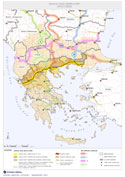
In addition, every indicator uses specific field-related standards of implementation, which are the zones of impact of the Egnatia Motorway. The zone of impact of a transport axis of the scope and importance of the Egnatia Motorway constitutes a dynamic system that becomes itself the outcome of the type and of the chronological span of every one of these impacts. Taking into joint consideration the theoretical background of the existing regional and spatial planning system and the applied methodology and practice, five zones of influence were established. These were determined as follows: first, the zone of the axis itself to a depth of 500-1,000 metres; second, the widest geographical area of the prefectures and regions which are traversed both by the axis of the Egnatia Motorway and by its vertical axes; and third the widest area in the Greek and Balkans territory which is affected as a result of the changes brought about by the axis and its vertical tributaries to the organization of the transport system as a whole.
ZONE I
|
Axis Zone |
500-1.000 on either side of the axis |
ZONE II |
Zone of transit of the axis |
Prefectures crossed by the axis (11 prefectures)
|
ZONE III |
Zone of transit of the transversal tributary axes |
Prefectures crossed by the transversal axes (13 Prefectures)
|
ZONE IV |
Zone constituted by the Regions |
Combination of Zones II and III (5 Regions)
|
ZONE V |
Wider zone of impact of the Egnatia Odos system |
Wider region of the Greek and Balkans territory
|
ZONE V-A |
Zone of impact on Greek territory |
Central and Western Greece , Attica , Northern Aegean Region and Ionian Islands
|
ZONE V-B |
Cross-border zones of impact |
As far as the capital cities of the countries of South-Eastern Europe sharing cross-border zones
|
WIDER/GREATER REGIONAL ZONE |
European zone of impact |
Running of the Egnatia Odos system as a portion of the Trans-European networks (TENs-T) and of the Pan-European Roads.
|
Taking a macroscopic perspective of the basic impact of the Egnatia Motorway and keeping in mind the fact that the development and land-planning projections are made on the basis of programmes on the Regional level, the key area on which the research on the evolution of the indicator measurements monitored by the Observatory focuses is Zone IV, that is, the Zone comprising the five Regions traversed by the Egnatia Motorway and its vertical axes: Western Macedonia and Thrace, Central Macedonia, Eastern Macedonia, Epirus and Thessaly. Zone IV is formed by Zones I, II, and III: these are the zones corresponding to the distance up to 1000 metres from the axis, the Prefectures crossed by axis, and the Prefectures crossed by the vertical axes, respectively. A number of indicators focus on Zones I, II and III, depending on the subject of the monitoring and on the geographical span involved. |