THE EGNATIA MOTORWAY OBSERVATORY
Monitoring the developmental, spatial, environmental and transport impacts of the construction and operation of the axis
=========================================
  RESEARCH STUDY ON ACCESSIBILITY INDICATORS FOR PLACES OF
SPECIAL INTEREST IN THE IMPACT ZONE OF EGNATIA ODOS MOTORWAY (TEN-T core), GREECE: EXECUTIVE SUMMARY (.pdf) RESEARCH STUDY ON ACCESSIBILITY INDICATORS FOR PLACES OF
SPECIAL INTEREST IN THE IMPACT ZONE OF EGNATIA ODOS MOTORWAY (TEN-T core), GREECE: EXECUTIVE SUMMARY (.pdf)
RESEARCH STUDY OF LAND USE, LAND VALUE AND BUSINESS LOCATION CHANGES IN THE IMPACT ZONES OF EGNATIA ODOS MOTORWAY (TEN-T core), GREECE: EXECUTIVE SUMMARY (.pdf)
==========================================
 ORIGINAL ARTICLE: "The Territorial Impact Assessment of transport: the case of the Egnatia motorway system in the cohesion potential of Southeast Europe", ORIGINAL ARTICLE: "The Territorial Impact Assessment of transport: the case of the Egnatia motorway system in the cohesion potential of Southeast Europe",
-
Authors: Nikolaos Gavanas , Efthimios Moutsiakis, Anastasia Tasopoulou, Eleni Verani & Vasilios Fourkas
Impact Assessment and Project Appraisal Journal (2018):
Received 23 Oct 2017, Accepted 22 Dec 2017, Published online: 04 Apr 2018, Published on behalf of the International Association for Impact Assessment
===========================================
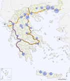
New maps: Trans-European Transport Networks (TEN-T)
 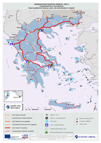
source: GIS dymanic maps of TEN-T (EC, DG MOVE, TENtec, 2017)
==========================================
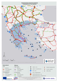
The Egnatia Motorway is a Trans-European Transport Networks (TEN-T) priority project. It represents a major investment in the transportation infrastructure of Northern Greece assisting the development of the region specifically and SE Europe in general.
Both the importance and the size of the investment necessitate the promotion of actions supplementary to construction that would multiply the benefits and mitigate the impacts from operation.
EGNATIA ODOS S.A. established and operates the Egnatia Motorway Observatory in order to: (a) support the integrated management of the motorway, (b) contribute to the utilization of the project in the cohesion and development of Northern Greece and the greater area of SE Europe, and (c) contribute to the harmonized assessment of impacts of Trans-European Transport Networks on the cohesion of the European area.
The Egnatia Motorway Observatory, based on documented scientific methods and the development of modern infrastructure of information systems collects, processes, and provides valid and updated data concerning parameters such as:
• the mobility in and accessibility to regions, urban centres, markets, and services,
• the development level, the cohesion degree, the competitiveness, and the intraregional inequalities,
• the building development and the networking of urban centres,
• the properties of the transport system and the operation of the road network, and
• the quality of the environment.
Through the Observatory, EGNATIA ODOS S.A. takes cares of the assessment of spatial impacts of the Egnatia Motorway and vertical axes system in relation to the project implementation progress, i.e. in relation to “before” and “after”. In this way the impacts on the social and economic cohesion shall be determined, as well as on the territorial planning, the transport system, and the environment in Northern Greece. The results, reports, and generally the material produced by the Observatory is supplied to the public and interested agencies over the Internet and through leaflets, events etc.
The objective of the Egnatia Motorway Observatory is to collect and process data, and calculate indicators to be used for monitoring the long-term impact of the motorway on the social and financial cohesion, the physical planning arrangement, the system of transport, and the environment.
The Observatory is being developed as a strategic tool providing information and support to policies and programmes of development planning, at the service not only of the EGNATIA ODOS A.E. but of all Regional and National Authorities and development agencies of the greater impact area of the axis.
The overall objective of the Egnatia Motorway Observatory is to:
• Produce direct and continuous output on an annual basis.
• Promote the cooperation and networking with similar organizations both at a national and international level, as well as with developmental agencies in the wider impact area of the motorway.
The results, reports, and generally the material produced by the Observatory is supplied to the public and interested agencies over the internet and through leaflets, events etc.
The Egnatia Motorway Observatory is the only Greek Observatory of Transports with a permanent organization and operation. It is a Unit of EGNATIA ODOS A.E. under the Support Services Division. By creating the Observatory and incorporating it in the existing structure of EGNATIA ODOS A.E. the maximum possible compatibility and complementarity with the other activities of the company is achieved, and at the minimum possible cost, as the existing human resources and equipment are utilized in a more rational and effective way.

The National Transport Plan for Greece – NTPG is a consultancy project awarded under the Framework agreement to support European Investment Bank’s Advisory Services (EIBAS) activities inside and outside EU-28. The primary objective of the Project is to provide the basis for sustainable transport infrastructure and service development in Greece over the medium to long term, which will contribute to the competitiveness of the transport sector of the country.

|